History

May 10, 2017

The history of New York’s Newspaper Row, the epicenter of 19th century news

While the news industry today continues to shift from bustling offices to laptops in coffee shops, it may be hard to imagine that the publishing industry was at the epicenter of some of the world's most important architectural feats. But this was the case in late 19th century New York City, when the daily newspaper industry was centered at Park Row, near City Hall. Such institutions included The New York Times, The New York Tribune and The New York World. 
Take a trip back in time with us and explore Newspaper Row
May 9, 2017

Did you know the idea for G.I. Joe was created in Brooklyn?

Did you know G.I. Joe, considered the world’s first action figure, was first conceptualized in Brooklyn? The famous toy was invented by NYC native Stanley Weston, who passed away this month at 84 years old. Weston, born in Brooklyn in 1933, sold his idea for a military-themed toy to Hasbro for $100,000 when he was just 30 years old. Hasbro later turned it into a $100 million success, with more generations of the dolls, comic books, a television series and movies following it.
Find out more
May 5, 2017

1932 map illustrates a vibrant nightlife during the Harlem Renaissance

During the Harlem Renaissance, some of the greatest black jazz musicians, poets, artists and writers of all time emerged in New York City between the 1920s and 30s. Thanks to an animated map acquired by Yale's Rare Book and Manuscript Library, we can get a sense of the vibrant nightlife of Harlem during this time in history (h/t Slate). This original pen-and-brush map was drawn by Elmer Simms Campbell, one of the first commercially successful, and syndicated, African-American cartoonists in the country. The map faces southwest, bound by 110th Street, and highlights the main attractions on Lenox and Seventh Avenues.
Find out more
May 4, 2017

Terra cotta figures that adorned building demolished for One Vanderbilt construction seek a new home

A rescued collection of terra cotta building facade figures–including naked cherubs, smiling porpoises and the head of Neptune–that once adorned an 18-story office building next to Grand Central Station are in need of a new home. The building was demolished to make way for the under-construction One Vanderbilt skyscraper; at the urging of New York Landmarks Conservancy Chair Lloyd Zuckerberg, the new building's developer, SL Green Realty Corp., saved the three terra cotta panels from the facade of 51 East 42nd Street. Warren and Wetmore, the building's architects, also designed the station.
Find out more
May 3, 2017

EVENT: Two food-centric tours explore the history and culture of the East Village

When we point the finger at gentrifying neighborhoods, the East Village often gets a lot of heat thanks to its quickly climbing rents, shift from a more diverse population (today, roughly 40 percent of the ‘hood is between the ages of 20 and 34), and loss of small businesses. And though this final fact is certainly true, especially as it pertains to eateries (just this past year we said goodbye to Angelica Kitchen, The Redhead, and Lanza's), the East Vill still has a wealth of independent restaurants that pay homage to its rich immigrant history as well as a crop of new establishments that are sensitive to the community and represent the new wave of foodie culture.  This weekend, two events will explore the past and future of the East Village through its food establishments--a walking tour led by 6sqft's Senior Editor Dana Schulz for GVSHP will take you through the Italian, Ukrainian/Eastern European, and Indian history and A Taste of 7th Street will offer a self-guided chance to taste samplings from 10 local favorites.
more details here
May 3, 2017

VIDEO: Robert Moses talks about roads, parks and city traffic in 1953

Robert Moses, the "master builder," was arguably the most influential individual in the development of New York City's politics and physical structure. He's widely known for his hand in creating New York State's massive parkway network (he built 13 expressways through NYC) and erecting large public housing complexes in low-scale neighborhoods (many of which were segregated), and has therefore been named as the source of many of the city's gentrification and urban decline issues still present today. Regardless of this criticism, his breath of knowledge and experience was unparalleled (we can also thank him for Lincoln Center, Jones Beach, and countless public swimming pools) and is the subject of this 15-minute television program called Longines Chronoscope that aired in 1953, at the height of his heyday.
Watch the video here
May 2, 2017

EVENT: Learn about the history of Tudor City, its micro-apartments, and its struggle to save its parks

Can you locate Tudor City on a map? Did you know it was a development used to clear out undesirable slums along the waterfront? Have you heard it contains more than 2,200 apartments smaller than 400 square feet—"the antique mother load of micro-living"? As far as New York City's hidden gems go, Tudor City is a neighborhood that is often overlooked. But if you're one who is interested in history, architecture, urban design, or all of the above, this verdant east side enclave is one that deserves at least an hour or two of exploration. On May 5th, 6th and 7th you'll get a chance delve deep into the history of this incredible 11-building development, as local historian and activist Brian K. Thompson leads several free public tours through early 20th-century development.
more details here
April 28, 2017

Five million dead in Queens: The history of New York City’s ‘cemetery belt’

You may have noticed when driving from Queens to Brooklyn that at some point you find yourself surrounded by a sea of headstones in every direction. The city's "cemetery belt"–reportedly visible from space–stretches for two and a half miles along the Queens/Brooklyn border and is so populous that there are more than twice as many dead people in Queens than living ones. What's up with this cemetery city?
Find out why the dead outnumber the living in Queens
April 27, 2017

NYPL’s ‘digital time travel’ maps let you compare today’s New York City with the past

6sqft previously reported on the "time machine" map function that allowed users to navigate overlaid maps from 1600 to the present to see what used to occupy our favorite present-day places. Now, the New York Public Library has released the Space/Time Directory, a “digital time-travel service” that puts the library’s map collection–including more than 8,000 maps and 40,000 geo-referenced photos–to work along with geospatial tools to allow users to see the city’s development happen over more than a century, all in one convenient place. Hyperallergic reports that the project, supported by a grant from the Knight Foundation, plots 5,000 digitized street maps across the five boroughs, organized by decade from 1850 to 1950.
Find out more
April 26, 2017

Hear the natural sounds that made up life in 17th century Manhattan (interactive)

For most modern New Yorkers, it’s hard to imagine the city being anything more than a crowded, noisy, concrete jungle. However, with the website Unsung.NYC, users can now explore the natural sounds of Manhattan, present during the 1600s before European settlers arrived. As the Times reports, “Calling Thunder” lets listeners hear all the chirps, croaks, and laps of waves, all of which coincide with images from four main points in Manhattan—the Collect Pond Park, the High Line, the American Museum of Natural History, and the Inwood Hill Park.
learn more here
April 26, 2017

New Jane Jacobs documentary spotlights her achievements in NYC and lessons to be carried forward

One of the most iconic battles to decide the fate of New York City was waged, in the 1950s and '60s, by Jane Jacobs and Robert Moses. He, a Parks Commissioner turned power broker, was known for his aggressive urban renewal projects, tearing tenements down to build higher, denser housing. She, often dismissed as a housewife, emerged as his most vocal critic—not to mention a skilled organizer with the ability to stop some of Moses' most ambitious plans. A new documentary, Citizen Jane: Battle for the City, takes a close look at the groundbreaking work of Jane Jacobs and its importance in our urbanizing world today. Matt Tyrnauer, the director behind Valentino: The Last Emperor, compiled footage of both Jacobs and Moses alongside 1950s and '60s New York, which is paired with voiceovers of Marissa Tomei and Vincent D’Onofrio as the battling duo. Experts in urban planning—everyone from Paul Goldberger to Robert A.M. Stern—also discuss Jacobs’ massive influence on housing policy and urban planning, as the film makes a convincing argument that Jacobs' planning philosophies are needed now more than ever.
Read our review of the film
April 24, 2017

‘Beerdom’ map shows 19th century Lower East Siders drank more

While today’s Lower East Side has no shortage of bars and clubs, New Yorkers of the late nineteenth century may have imbibed way more than current Big Apple dwellers. Slate shared this map drawn in 1885 and published in the Christian Union that details the number of bars per block in the neighborhood. Although the coinciding article described the social effects of LES drinking culture, overall the report found residents to be quite happy. It may have had something to do with the 346 saloons found in the area, compared to today’s mere 47 establishments. 
Find out more
April 21, 2017

The history of NYC’s Quonset Huts, Robert Moses-era veterans housing

When veterans returned to NYC from WWII, they were met with a Depression-era housing shortage that resulted from a nearly 15-year lack of new development. To immediately address the issue, "master builder" Robert Moses (who by this time was reigning over the city's public housing projects) proposed erecting Quonset huts on vacant land in Brooklyn and Queens. These curved, corrugated steel "shacks" were used in the Pacific as barracks and offices, as they were lightweight and quick and easy to assemble. As the Brownstone Detectives tell us, after much debate, the city agreed to use more than 500 Federal surplus huts as temporary public housing on land along the Belt Parkway in the South Brooklyn neighborhoods of Canarsie and Jamaica Bay, as well as in Jackson Heights, Middle Village, and Corona in Queens.
Get the whole history
April 21, 2017

The Urban Lens: Explore the whimsical photography of Todd Webb with former LIFE editor Bill Shapiro

"I instantly fell in love with Webb’s work," says former LIFE editor-in-chief Bill Shapiro, "with the beauty he captures, with his sense of the life of the street; with the way he frames both the sweeping, iconic skyline and those small, fleeting moments that define the city that New Yorkers love." These sentiments seem to be shared by just about everyone who encounters the work of Todd Webb for the first time. Webb, most fittingly described by Shapiro as "the best NYC photographer you've never heard of," worked and laughed alongside photography's upper echelon, including Georgia O’Keeffe, Walker Evan, Gordon Parks and Ansel Adams, but unlike his well-known friends, Webb was never interested fame. Instead, he quietly took to documenting life in America, particularly post-war New York between 1946 and 1960.
more on the work of todd webb here
April 20, 2017

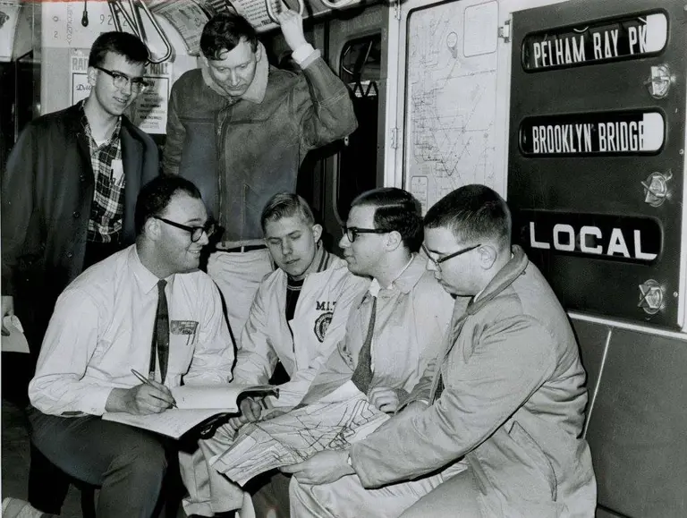
50 years ago, computer expert Peter Samson started the ‘subway challenge’

In May of 1940, electric railroad enthusiast Herman Rinke became the first person to tour the entire New York City subway system on a single token, putting in 25 some hours underground all for fun. After reading about Rinke’s journey, Peter Samson, a computer software engineer who later invented the world’s first video game Spacewar, decided to take a stab at making his own record. As the Times recounts, he formed the Amateur New York Subway Riding Committee (ANYSRC) to develop rules for the challenge. After one failed attempt in 1966, Samson, with the help of 15 volunteers and a computer program that tracked the fastest route, completed the trip in 25 hours, 50 minutes and 30 seconds on April 21, 1967. Since then, the subway challenge has taken off for puzzle and transit lovers worldwide.
Find out more
April 13, 2017

Why is New York City called the Big Apple?

Most of the nicknames ascribed to New York make literal sense: Gotham; Empire City; the City That Never Sleeps; the City So Nice They Named It Twice. However, the context behind the “Big Apple” nickname isn’t as obvious. To help us understand the moniker, the New York Public Library detailed a history of the name, taking us through a tour of what “big apple” has meant throughout centuries.
Find out more
April 10, 2017

Past Prisons: Inside the new lives of 7 former NYC jails

The past week has been full of news about Rikers Island and Mayor de Blasio's announcement that the notorious prison will be closed and replaced with smaller facilities throughout the boroughs. Ideas for re-use of its 413 acres have included commercial, residential and mixed-use properties; academic centers; sports and recreation facilities; a convention center; or an expansion of nearby LaGuardia airport. And while anything final is estimated to be a decade away, this isn't the first prison in NYC to be adaptively reused. From a health spa to a production studio to a housing development, 6sqft explores the new lives of seven past prisons.
READ MORE
April 7, 2017

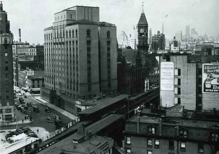
The Urban Lens: Sid Kaplan shares historic photos of the Third Avenue El coming down

6sqft’s ongoing series The Urban Lens invites photographers to share work exploring a theme or a place within New York City. This week’s installment comes courtesy of a new exhibit at the Transit Museum, "Deconstruction of the Third Avenue El: Photographs by Sid Kaplan." Are you a photographer who’d like to see your work featured on The Urban Lens? Get in touch with us at [email protected]. After the city consolidated its underground subway lines in 1942 (they were previously owned by private companies), fewer New Yorkers were riding the elevated lines. This decreased ridership, along with the fact that the Els ate up valuable street-level real estate and created dangerous dark spaces, led to the city taking down the Second Avenue Elevated line in 1942. In 1955, the Third Avenue Elevated came down as well, catching the eye of a then 17-year-old Sid Kaplan, whose photos of the dismantling are currently on display at the Transit Museum’s Grand Central Gallery Annex. The museum tells us, "From his perch on the roof of an apartment building, or leaning out the window of an office, his images capture a unique perspective of the removal of a hulking steel structure, the hard-working people who dismantled it, and the ever-changing landscape of New York City."
More on the El history, Sid's work, and all the amazing photos
April 4, 2017

Explore the homes of NYC’s notable writers with an audio-narrated tour

Some of the greatest literary giants of all time lived and wrote in New York City. In celebration of the 200th anniversary of HarperCollins, which was founded in NYC, the publishing company created an interactive walking tour map that narrates the history of each author as you walk (h/t DNAinfo). Just a few of the famed Big Apple authors include Harper Lee, Mark Twain, Zora Neale Hurston and Richard Wright.
Find out more
March 30, 2017

From the Westside Cowboys to the Oreo cookie: 10 Secrets of Chelsea Market

Today it seems like there's a new food hall popping up every day, but one of the first incarnations of this trend was at Chelsea Market, when Irwin Cohen and Vandenberg Architects transformed the former Nabisco factory in the 1990s into an office building, television production facility, and food-related retail hub. New York City history buffs likely know that this is where a certain famous cookie was invented, but there are plenty of other fun facts about the location that are much less well known. Therefore, 6sqft has rounded up the top 10 most intriguing secrets of Chelsea Market.
Find out everything here
March 30, 2017

MAP: How old are the buildings in each Brooklyn neighborhood?

Photo via Brooklyn Historical Society One of the most exciting things about exploring Brooklyn is seeing the unique architecture of each neighborhood. Now, thanks to an interactive map from urban_calc, you can also learn the age of these structures in the borough with the oldest buildings in the city. Using the city’s OpenData project and Pluto dataset, urban_calc found the median age of buildings in each census tract. The oldest neighborhood is Ocean Hill at 1911, followed by Cypress Hill, Park Slope and Stuyvesant Heights, all with a median building year of 1920. On the other hand, the newest neighborhoods include Coney Island, West Brighton, East New York, Canarsie and Williamsburg.
Find out more here
March 28, 2017

Explore historic LGBT sites in NYC with this interactive map

To broaden people's knowledge of the lesbian, gay, bisexual and transgender community’s history in New York City, the NYC LGBT Historic Sites Project created a map-based online archive to document significant sites throughout the five boroughs. Although earlier maps highlighting LGBT history have been created, they focused solely on the history of Greenwich Village, the hub of gay activism. But the new interactive map, based on 25 years of research and advocacy, hopes to make “invisible history visible” by exploring sites across the city related to everything from theater and architecture to social activism and health.
Learn more here
March 22, 2017

On this day in 1811, the Manhattan Street Grid became official

Deemed by historians as the "single most important document in New York City’s development," the Commissioners’ Plan of 1811, which planned Manhattan's famous grid system, turns 211 years old this month. As the Village Preservation tells us, the chief surveyor of the plan, John Randel Jr., and city officials signed the final contract on March 22, 1811. The plan, completed at the end of the 19th century, produced 11 major avenues and 155 cross-town streets still used today.
Learn more here
March 22, 2017

Remembering New York City’s days of deadly smog

Over Thanksgiving weekend in 1966, the layer of smog that hung above New York City killed about 200 people. An estimated 300–405 people died during a two-week smog episode in 1963. In 1953, as many as 260 died from breathing the city's air over a six-day stretch. 6sqft reported recently on Donald Trump's proposed budget and subsequent concerns about the impact significant funding cuts to the Environmental Protection Agency totaling $2.6 billion or 31 percent–including staff reductions and program eliminations–might have on the city’s drinking water and air quality. A spokesman for Mayor de Blasio assured us that these federal cuts won't impact NYC’s high quality water supply. But what about the air?
But what about the air?
March 22, 2017

Rent in the Greenwich Village building where Alexander Hamilton purportedly spent his final day

Alexander Hamilton and Aaron Burr may have dueled in Weehawken, New Jersey, but they also both left their mark on Greenwich Village. At the end of the 18th century, Burr began buying up land around Bedford and Downing Streets for his Richmond Hill country estate (a Federal rowhouse here recently hit the market for $5.75 million). Hamilton's connection is much less glamorous: On July 12, 1804, the day after the duel, he died in the home of his friend William Bayard. According to a plaque on the building, this took place at 82 Jane Street, where a listing for a $3,495/month one-bedroom also backs up the claim. But historians say Bayard actually lived a block north on Horatio Street.
READ MORE